
A look at 8 new UNESCO Global Geoparks
Earlier this month, UNESCO designated eight new UNESCO Global Geoparks, which brings the number of sites participating in the Global Geoparks Network to 169 in 44 countries.
These newly designated UNESCO Global Geoparks are:
Vestjylland UNESCO Global Geopark, Denmark
About one-third of the Geopark's surface area is on land, the rest consisting of marine areas in the Limfjord and the North Sea. The terrestrial part of the Geopark's hilly glacial landscapes with flat outwash plains, lagoons and lakes was formed by successive ice ages, particularly the most recent ice age, the Main Advance, that took place 23,000 to 21,000 years ago. Wind and water have continued to impact the landscape in many highly visible ways. The Geopark comprises 13 Natura, 2000 sites and five nature and wildlife reserves encompassing more than 90 geological and natural sites.
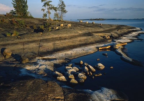
Saimaa UNESCO Global Geopark, Finland
The Geopark takes its name from Lake Saimaa, the largest lake in Finland, and fourth largest lake in Europe. Situated in southeast Finland, south of the Vuoksi water system, the Geopark spans an altitude of about 20 to 180 metres above sea level. One-third of its surface area is water, dotted with thousands of islands, with a combined shoreline of over 8,000 kilometres. Saimaa's rock foundation points to the area's ancient past when it was part of the seabed some 1,900 million years ago. The area's soil was formed over the last 20,000 years as a result of ice sheet erosion. Since then, a number of unique and endangered species, including the Saimaa ringed seal and landlocked salmon, became isolated in the area. Impressive rock paintings on the shores of the lake indicate human presence since the Stone Age.
Thuringia Inselsberg -- Drei Gleichen UNESCO Global Geopark, Germany
Located in Thuringia, central Germany, the Geopark covers an area of about 988 kme at altitudes ranging from 250 to 900 metres above sea level. Its geology documents over 150 million years of the Earth's history, from the amalgamation of the supercontinent Pangea until its break-up in the Late Triassic, and it features the only outcrop of the Triassic/Jurassic boundary in central Germany. The Geopark's extraordinary fossil record has been the subject of research for over 300 years leading to the accumulation of great geological expertise. Its fossil reefs, among the first to be recognized as such in the 19th century, are the remnants of the formation of a small island surrounded by reefs in the Zechstein Sea. Visitors can explore three of the Geopark's hundred natural caves.
Grevena -- Kozani UNESCO Global Geopark, Greece
In the north of Greece, in the region of West of Macedonia, the Geopark covers an area of 2,486 kme, with altitudes ranging from about 380 to 3,800 metres above sea level. Greece's longest river, the Aliakamon, flows through it. Its geology comprises rock formations dating back from about one billion years ago to the present documenting several tectonic plate events including the birth of the Tethyan Ocean and the emergence of Europe as a distinct continental mass. Studies of these geological features contributed significantly to development of the prevailing theory regarding the origin of tectonic plates. The Geopark also features some of the world's most important proboscidean fossils, the Lands of the Elephants, and the world's longest known mammoth tusk, over 5 m long.
Belitong UNESCO Global Geopark, Indonesia
The Geopark is located approximately 400 kilometres to the north of Jakarta and encompasses Belitung Island and over 200 small islands in a marine area of 13,000 kme. The marine area represents about two-thirds of the Geopark's total surface area. Belitong is known for its spectacular Tor granite landscapes, landforms of large, free-standing rock outcrops created by erosion and weathering. It also features rare tektites formed by meteorite impacts known as Satam Stone or Billitonite and unique mineral deposits such as the Nam Salu primary tin deposit, the wealthiest single tin lode in the southeast Asia region. Located on historic maritime trading and migration routes, the Geopark is home to over 288,000 people of diverse cultures including the Sawang Tribe.
Aspromonte UNESCO Global Geopark, Italy
Located in Calabria in the south of Italy, rising from sea level to almost 2,000 metres, the Geopark is home to over 273,000 people. Its peculiar geology is the result of a geodynamic and seismotectonic evolution that started more than 500 million years ago and is still ongoing. A complex of mountains, ridges and plateaus alternates with deep valleys carved by unique natural water streams called fiumare, which have sculpted the hard rock of the crystalline-metamorphic substrate overtime and created spectacular waterfalls.
Majella UNESCO Global Geopark, Italy
Located in the Central Apennines, the Geopark covers a surface area of 740 kme with an altitudinal range of 130 to 2,800 metres above sea level featuring more than 60 peaks in the Majella Massif, half of them exceeding 2,000 metres, as is the case with Mount Amaro. Exhibiting one of the youngest reliefs of the Apennines, the area is constituted mainly by fossil-bearing limestone. With remnants of human presence going back about 600,000 years, the Geopark contains 95 geosites, including one of the oldest archaeological geosites in Europe.
Holy Cross Mountains UNESCO Global Geopark, Poland
Located in the southeast of Poland, in the western part of the Swietokrzyskie (Holy Cross) Mountains, the Geopark's altitude ranges from 200 to 400 metres above sea level and is home to more than 2,52,000 people. The Geopark lies within the Trans-European Suture Zone (TESZ), a major tectonic boundary between the Variscan West-European Platform, Precambrian East-European Platform and orogenic belt of Alpine structures, which are key to understand the geological structure of Europe. Traces of human activity in the Geopark dating back 60,000 years, include Neanderthal camps and beautiful cave systems. Many ancient quarries and mines bear testimony to the importance of mineral deposits, metal ore, limestone, and other natural resources for local populations through the ages.